Formerly Picardie and Nord-Pas-de-Calais

Description
Hauts-de-France is an administrative region in the north of France, created by the territorial reform of 2014. The result of the merger of
Nord-Pas-de-Calais and Picardy (themselves created in 1972), it was first provisionally called Nord-Pas-de-Calais-Picardy. It covers 31,806
km2 and includes five departments: Aisne, Nord, Oise, Pas-de-Calais and Somme. Its capital is Lille, the region’s main city and previously
the capital of Nord-Pas-de-Calais. Amiens, capital of the former Picardy, is the second largest city in the region.
The region is bordered to the north by the North Sea for 45 kilometres and to the west by the English Channel for more than 120 kilometres.
On the other side is Kent in the United Kingdom, 35 kilometres away. On the land side, the region borders Belgium (Hainaut and West
Flanders) to the north-east, from Bray-Dunes to Watigny, for more than 350 kilometres. It also borders Normandy to
the West, Ile-de-France to the South and the Grand Est to the East.
Located in the heart of Europe, with 6,009,976 inhabitants on 1 January 2015, and a population density of 189 inhabitants/km2, it is the 3rd
most densely populated region in France and the 2nd most densely populated in mainland France after Île-de-France.

The region is located in the north of France: the commune of Bray-Dunes is the most northerly point of the region, all territories combined.
Stretching between the 49th and 51st northern parallels, the region covers an area of 31,806 km2, or 5.8% of French territory. Like the rest
of mainland France, it is in the Central European Standard Time time zone and, at the time of the changeover to summer time, it is in the
Central European summer time zone.
History
It is a territory with rather contrasting origins. Until the 18th century, it was divided into several provinces, the main ones being
Picardy (around Amiens, Saint-Quentin, Boulogne and Calais), Flanders (around Lille and Dunkirk) and Artois (around Arras, Lens and
Béthune), while Ile-de-France extended as far as Beauvais, Compiègne and Laon. Even today, geographical, cultural and economic differences
can still be found in this historical delimitation and some of these appellations are still commonly used. The French Revolution marked the
creation of today’s departments.
The border position of the Hauts-de-France made it a strategic economic and military place. It has always been at the heart of major
conflicts: during the Medieval Ages and recent history with the two World Wars.
- 1916: Battle of the Somme, one of the bloodiest battles of the First World War.
- 11th November 1918: signature of the armistice between France and Germany, at Rethondes (forest of Compiègne).
- 22th June 1940: signature of the armistice between France and Germany, in Rethondes (forest of Compiègne).
Nord-Pas-de-Calais & Picardie Flags
Nord-Pas-de-Calais
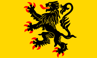
It is Based on the crest of the Flandre county. “Lion of Flandres appearing”, used on the flag of the Belgian Flanders (located partly in
the west of Belgium). It is also sometimes used for French Flanders (western department of northern France). Artois and Hainault (adjacent
to this area) have different flags, as well as the Nord-Pas-de-Calais)
Picardie
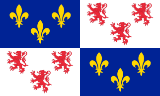
It is based on the seal of the Picardy Nation at the University of Paris. There is the LYs flower, the symbol of the old French royalty on
the royal blue background and the “Lion of Flandres”.
Culinary Specialities
Potjevleesch & “Ficelle picarde“
Wine:
Meat:
-
Potjevleesch: Pieces of chicken, rabbit, pork and veal meat, cold and set in slightly vinegar jelly. The potjevleesch
is usually served with French fries, or in the traditional way with Dunkirk apples (peeled apples cut in half, or in four, half boiled in
water and then finished by frying).
-
Carbonnade flamande: Composed of pieces of meat simmered in a beer sauce with onions. It is sometimes prepared with
gingerbread and a little brown sugar. Note that the fries that accompany this dish are very often prepared in beef fat.
-
Terrines and pâtés du Nord: Through different suppliers, we offer you many terrines from producers of the region with
specialities of the region such as salicornes, maroilles, chicory, sea buckthorn, northern garlic, beer, juniper…
-
Waterzoï: Chicken or fish based. It is a unique dish of chicken or fish, accompanied by vegetables, served in a soup
tureen and soup plates, whose broth or stock is bound with cream or butter. Enjoy it with potatoes or pasta.
-
“Ficelle picardes”: crêpe au gratin which is garnished with mushrooms, ham and shallots. According to
tradition, it is the crème fraîche and not the béchamel sauce that is used for the real Picardy strings.
-
Andouillette from Arras: Handmade, usually made with pork strawberry, shallot, parsley and mustard, which is wrapped
in a fairly strong beef menu.
-
Every year in August, the city of Arras celebrates its andouillette with a festival that is an opportunity to attend a culinary competition
or a colourful parade.
Waterzoï & Mussels & French Fries
Fish & From The Sea:
-
Waterzoï: The original dish is often made of fish, either freshwater or sea, though today chicken waterzooi is more common.
-
Fish soup: It is in Le Touquet-Paris-Plage that seafood lovers will be able to enjoy excellent fish soups accompanied,
as desired, by garlic croutons, rouille and grated cheese.
- Mussels & French fries
Vegetables & Vegetarian:
-
“Flamiche au maroilles”: A savoury pie with vegetables or cheese. While
there are several versions with leeks, onions or endives, the Maroilles tart is the most famous. The leavened dough is covered with slices
of this typical regional cheese and fresh cream.
-
“Flamiche picarde”: A savoury tart of Flemish origin, the flamingo is in
Picardy a kind of leek pie that can be found in all the traditional restaurants of the region. The Picardy flamingo consists of puff pastry
or shortcrust pastry, sliced leek whites that have been sweating in butter, fresh cream, eggs and salt.
“Bêtise de Cambrai” & Filled waffles
Cheese:
-
Maroilles: Soft cow’s milk with a washed rind and a full-bodied taste, which is produced exclusively in the Avesnois
and Thiérache regions of France
-
And other name: Belle des champs, Dauphin, Manicamp, Baguette paysanne à la moutarde, Bergues, Boulet de Cassel,
Boulette d’Avesnes, Boulette de Cambrai, Briquette de l’Écaillon, Carré du Vinage, Larron d’Ors, Le Rouchi à l’échalote, Mimolette, Rollot,
T’chiot biloute, Tome de Cambrai, Ch’ti Crémeux, Cœur de Pommeau, Crémet du Cap Blanc Nez, Fort de Béthune, Le Sire de Créquy, Pavé aux
Algues de Samer, Trappiste de Belval, Vieux Boulogne, Vieux Samer et Tomme au foin
Desserts & Sweets:
-
Bêtises de Cambrai: the “Bêtise de Cambrai” (Cambrai nonsense), invented around
1830 by an apprentice confectioner following a recipe error, is a delicious mint flavoured candy with a caramelised sugar stripe, renowned
for its refreshing and digestive virtues.
- Amiens macaron: Real emblem of the city, the macaroon is made of marzipan, sugar, honey, eggs and vanilla.
-
Filled waffle: Its oval-shaped golden dough consists of flour, sugar, yeast, salt, butter and eggs. It is first baked
in a hand oven, before being opened in half and filled with a preparation based on butter, sugar, and a vanilla or rum flavor.
-
Chocolate of Beussent: “Mendiants” (beggars), chocolate tiles, simple bars, orangettes or delicious Mayan logs are all
specialities to be enjoyed with pleasure. Chocolate lovers will also have the opportunity to visit the production workshop during their stay
in Beussent.
-
Le gâteau battu: A pastry in the shape of a fairly high, crenellated cylinder, the beaten cake is rich in egg yolks
and butter. With its brown crust and golden-yellow crumb, this cake has a more airy texture than a brioche.
Are you hooked on the region? You want more information? I invite you to watch these interesting videos that make you discover the region
with different points of view.
For this article, I used these sources:

